Author of the Sturmtaucher Trilogy

Tag: Research

The Lie of the Land – Part 3

My visit to Denmark

**Spoiler Alert**

This post contains spoilers – please don’t continue reading if you have not previously read The Flight of the Shearwater, the second book in the Sturmtaucher trilogy. You have been warned!

1 Hamburg Airport 2 Brunsbüttel 3 Esbjerg 4 Kærgård beacon 5 Ringebjerg beacon 6 Blavlandshuk Lighthouse 7 Skallingen Lighthouse (site) 8 Skallingen Marshland 9 Hobo Dyb 10 Location of Lund Farmhouse 11 Middlefart Bridge 12 Flensburg 13 Schleswig 14 Rendsburg 15 Kiel

When I’d flown into Hamburg on my 2017 research trip, and picked up my little hired Fiat 500, I hadn’t headed straight for Kiel. I knew that part of my story would take place in Denmark, and I was on the hunt for a very specific location where a yacht could find shelter from a savage North Sea storm, out of sight of the German authorities occupying Denmark.

After a painstaking search, I thought I’d found the ideal place on Google Earth, but I wanted to make sure so, after a short detour to view the western sea locks of the Kiel Canal at Brunsbuttel, where it meets the River Elbe, and its access to the North Sea, I drove through the incredibly flat terrain of northern Germany and southern Denmark in the dying light, finally arriving at the port of Esbjerg on Denmark’s west coast, where I’d booked a room.

Brunsbüttel in the 1930s – the ferry Kranich would make an appearance in The Turn of the Tide
Brunsbüttel sea locks
3 Esbjerg 4 Kærgård beacon 5 Ringebjerg beacon 6 Blavlandshuk Lighthouse 7 Skallingen Lighthouse (site) 8 Skallingen Marshland 9 Hobo Dyb 10 Location of Lund Farmhouse

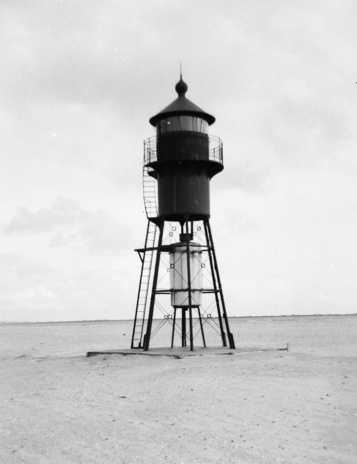
Fortunately, the rain had cleared by the morning, and it was a pleasant autumn day. I had a quick look around Esbjerg harbour – I knew the lightship that marked the end of Horns Rev, a long reef that extends over 20 miles from Blavlands Huk, or point, out in to the North Sea, had been preserved, and lay in the Harbour for tourists to explore.

Horns Rev lightship, Esbjerg

The treacherous sandy reef was to play a significant part in the book.

To my disappointment, the floating lightship museum wasn’t open, so I jumped back in my little Fiat, and headed northwards, following the road out of Esbjerg, through Oksbøl and Børsmose, the roads getting narrower as they approached the dunes beyond Kærgård. A rutted lane ending in sandy open circle brought me to my next destination. I could hear the sea, but I couldn’t see it, although I couldn’t miss the large tripod Kærgård sea mark, looking for all the world like an alien machine from War of the Worlds, high on the dunes above me.

Kærgård beacon
My little Fiat 500 behind the dunes at Kærgård

I climbed the sandy path through the scrub and tall Marram Grass, cresting the forty foot dune to find the North Sea surf crashing on the beach below, at the point where Der Sturmtaucher, with Franz, Johann, Ruth and Manny aboard, would make landfall in their search for Blavland lighthouse. The innermost marker of Horns Rev, it’s light would guide them through the storm to the entrance of Graa Dyb channel, and the sheltered waters of Ho Bught, Esbjerg and, more importantly, Ho Dyb, and its narrow tidal cuts among the marshlands behind the dunes of Skallingen.

Getting back in the car, I followed the narrow roads through the sandy, forested heathlands behind the dunes, looking for the next seamark and, as I passed through the campsite that now shelters behind the dunes, I could see the Ringebjerg Beacon clearly in the distance. Like Kærgård, it stood on three legs, a tripod with a diamond shape. Both structures are part of a chain of navigational mark that stretch all the way up the Jutland coast, and were erected in the late 1800s. They are all now protected monuments.

Ringebjerg Beacon

I could have easily walked from Ringebjerg to Blavlands Huk, or point, but time was short so I drove an inland loop round to the car park next to the lighthouse. It was this light, and the one that once mark the tip of Skallingen, that Franz and Johann would use to navigate their way to safety at the height of the storm that almost drowned them.

Blavlandshuk Lighthouse

From Blavlands point, I could see the troubled waters of Horns Rev stretching out far into the North Sea, the swirling currents a combination of tidal flow through the narrow channels of the reef, and the current flowing northwards from the Wadden sea, the coastal strip of water and islands that are the south-eastern limits of the North Sea, part salt, part fresh, from the large rivers, including the Elbe, which pour into it.

Horns Rev

I imagined the two terrified Nussbaums watching Franz and Johann wrestle their small craft through the crashing waves of the reef, threading their way through Søren Bovbjergs Dyb, the narrow break in the sandbanks that cut twenty horrendous sea miles from their passage to shelter.

Storm Waves

Once through it, they had searched for the lighthouse at the tip of Skallingen, the four mile long spit of sand dunes that protected Ho bucht and Ho Dyb from the ravages of the North Sea.

As I drove through the village of Ho, and out the single track road that took me to the car park half way along Skallingen, I knew I wouldn’t see the lighthouse – it had been removed in 1966 after subsiding foundations had caused it to collapse. The lightweight Iron Structure had replaced a substantial brick tower which had also collapsed, the perils of building on foundations of sand.

Skallingen lighthouse being demolished after subsiding
Skallingen lighthouse 1911 – 1966

I had to walk the last mile or so as the track wasn’t suitable for road vehicles (though I would have given it a go if it hadn’t been a hire car).

The walk along Skallingen

At the tip of Skallingen the dunes gave way to a half mile long low spit of sand and, standing at the water’s edge near to low tide, I could just make out the island of Fanø with it’s off-lying sandbanks on the other side of Graa Dyb. A ship passed by, heading out from Esbjerg, heading south and west, and I waved at its bridge. I couldn’t say for sure, but I thought my salute was returned.

The tip of Skallingen
Graa Dyb, Langli and Hobo Dyb

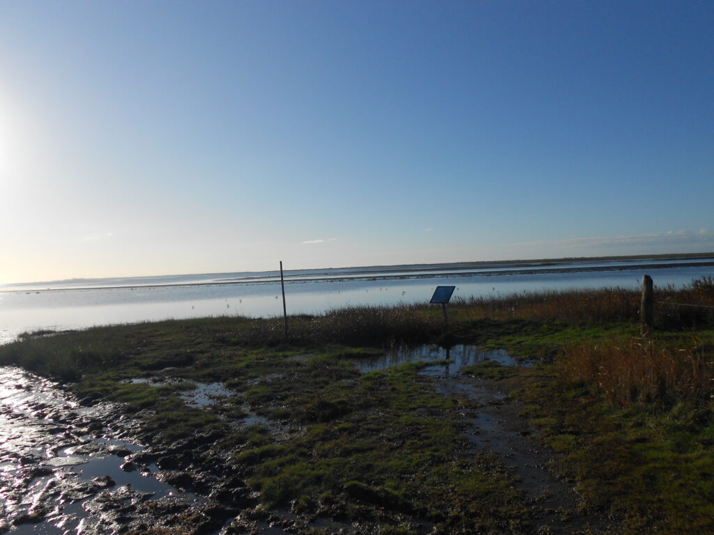
Turning landward, I could make out the narrow Ho Dyb channel that curled around the back of Skallingen, between it’s dunes and marshes and the low lying Island of Langli opposite, with its tail of sandbanks that guarded its entrance.

I imagined the calm that would welcome any boat brave enough to tuck itself into Hobo Dyb during the worst of storms. The only question I had was whether the boat would be hidden well enough to escape notice from the German authorities, so I retraced my steps along the track to the car, and drove the short distance to a bend in the road close to where I imagined Der Sturmtaucher would come to a rest if she’d made it to safety. I looked towards Ho Bught, but I couldn’t see Langli, far less Hobo Dyb.

I climbed the fence and made my way cautiously across the rough grassy hillocks, careful to avoid the odd mud filled hole that, as I ventured further towards the channel, began to coalesce into trenches, then water filled creeks. I looked around anxiously: I was on my own, with few people about, and it would be extremely perilous to get bogged down in one of these foul-smelling pits.

Even as the cut I was following opened out into a small, muddy, tidal creek, I still couldn’t see anything beyond the tall marsh grasses and I stopped, knowing that such a creek was an almost perfect hiding place for a wooden yacht, invisible from the road and the main channel.

The Marshlands and creeks behind Skallingen

Reaching the road again, I breathed a sigh of relief at having avoided being trapped in the mud. I drove back along Skallingen towards Ho, stopping when I reached the forest. Parking the car once more, I followed the edge of the forest around the top end of Hobo Dyb on foot. It was rough going, but dryer, and I could now see Langli, with Ho Bught beyond, and Hobo Dyb itself. I reached the small road which led around the shoreward side of the wood towards Ho. I looked out – the start of the rough causeway which could be supposedly traversed at low tide to get to Langli disappeared into the water and I didn’t fancy the walk or drive across it to get to the island, even if I had been there at low tide.

Langli
Ho Dyb. The start of the causeway to Langli is on the left.

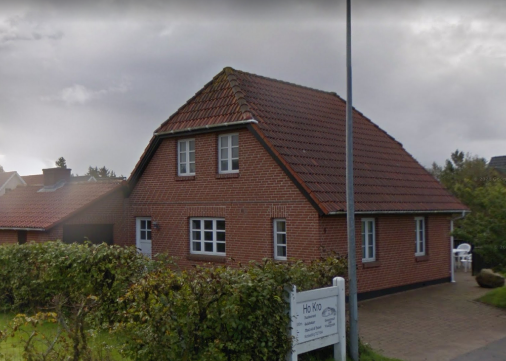
I followed the road around towards Ho but before I got to the village itself, I reached the road to Skallingen again. I looked around. I’d passed a golf course on my walk, and there were a modest number of what looked like holiday homes scattered within the forest, and at its edge. Most were modern but, as I approached Ho, there were some older looking houses among them. Back in 1941, they were probably all small farmhouses, surrounded by fields. In my imagination, the Danish farmers who provided help and shelter to Johann and Manny lived in one of these houses, working the land and fishing in the waters of Ho Bught and Hobo Dyb.

A typical Danish house near Ho, much like the Lund Farmhouse in my mind.

Walking back along the road to Skallingen to my Fiat 500, through the beautiful pine forest, a car slowed down and a Danish couple, with excellent English and a dog in the back, stopped and offered me a lift. They were locals, and were intrigued when I told them I was researching for a wartime book. They were intensely proud that almost all of Denmark’s Jews had survived the Holocaust.

Wishing me good luck with my writing, they drove off – I presumed for a walk along the dunes. I took one last look out at the North Sea and closed my eyes, imagining Der Sturmtaucher sailing out of Graa Dyb with the fog to hide them, heading westward for the east coast of England, and safety for Ruth and Manny, imprisonment for Franz and Johann.

The North Sea

I told myself that one day, I would follow their route, sailing from Kiel to Hobo Dyb, and onwards across the North Sea, but for now, I turned away and walked back down the dunes.

I got back into the car. I had a long way to go, and a few more stops to make.

I wanted to see the Little Belt, or Lillebælt, the westernmost of the three straits that connects the Baltic sea with the Kattegat and Skagerrak, and through them, the North Sea.

It was just over an hour’s drive across to Denmark’s other coast, to Middlefart and the old Bridge which crosses the Little Belt at its narrowest point. I’d studied the three routes Der Sturmtaucher might take from Kiel to Northern Denmark, and I’d decided the tighter, most difficult one close to the mainland would be their passage of choice, with less marine traffic, and a number of quiet harbours and anchorages where Ruth and Manny Nussbaum could remain undiscovered. I didn’t have time to visit the other stops on their journey; Hirtshalls, Laeso, Hjelm, Bogense and Bodjen, but when I looked out across the Middlefart Narrows, I felt that it was the right choice to have them follow the quieter channel. I looked over to the small town of Middlefart on Fyn, one of the large islands that make up almost a third of Denmark’s land area.

Middlefart Bridge and Narrows

I saw the narrow stretch of water, with the bridge and the small harbour opposite as somewhere Der Sturmtaucher might be stopped and searched on its way north with its illegal passengers on board, hiding in the bilges.

I didn’t stay long. The light would fade soon and I had a few more stops on the way to Kiel. I didn’t have to detour much from my route – Flensburg, Schleswig and Rendsburg were all on the road to my final destination.

Flensburg and Schleswig were much as I’d pictured them, both beautiful small waterside cities, their architecture largely unaffected by war, unlike Kiel. I had planned small cameo appearances for both places in the book, but neither would feature significantly.

Flensburg
Schleswig

It was the same with Rendsburg. Situated beside the Kiel Canal, with an offshoot, the Ober Eider, swinging right into the centre of town, the canal that made the inland city a port would play a bigger part in the book, and having seen the western sea locks at Brunsbüttel, and hoping to see the sea locks at Kiel, I wanted to see an inland section of this remarkable waterway, with no other locks along its 61-mile length.

Rendsburg and the Kiel Canal

The light was failing but, from Rendsburg, it was only a forty-minute drive to Kiel. Even so, I wanted to get there as sharply as possible to get something to eat and a few drinks down by the water front, to get an idea of night-time Kiel, and to get an early bed; the next few days would be full-on if I was going to see everything I wanted to in and around the city where the bulk of the Sturmtaucher Trilogy was set.

Kiel Waterfront at night

THE LIE OF THE LAND, Part 1 – My visit to Kiel, 2017

THE LIE OF THE LAND, Part 2 – My visit to Kiel the suburbs and surrounding areas

More detailed maps, and the routes the characters travelled can be found on the website, and you can download my route through Denmark on Google Maps

Please share to:

THE LIE OF THE LAND, Part 1

My visit to Kiel, 2017

When I started researching the Sturmtaucher Trilogy back in late 2016,  I was dismayed to find that, unlike most countries in Europe, Germany did not allow Google to roll out Streetview. At a stroke, my ability to walk the streets of Kiel and other parts of Germany from the comfort of my writing chair had gone, and while maps and old photographs were abundant and helpful, with a bit of digging, it was harder to get a real sense of the locations I was looking for as I plotted my story.

Europe. Only Belarus is as bereft of the dark green of Google’s Streetview as Germany.

In 2017, I visited Northern Germany to try and get a handle on the city that would become the centre of my life for the next five years, to get my head around its topography, and that of the countryside around it.

I also wanted to speak to the people who lived there, and walk the streets to see if any of the buildings that I’d located using 1930-40s maps and photographs were still there.

Holtenauerstraße, Kiel, in 1935, 1945 and 2015

I knew that large swathes of Kiel had been decimated during the latter part of WW2, and that the many of the buildings I wanted to describe had gone forever; the centre of Kiel is largely a new city, arising from the ashes of the old one, and when I arrived,  I found it more difficult than I imagined to place myself in the 1930s streets when modern roads and concrete buildings surrounded me.

Then I’d turn a corner and fragments of the old Kiel I’d seen in the photographs would emerge; the occasional row of apartment blocks that had survived; a church, a junction, an avenue of trees, and most of all, the parks and open spaces that had always been there for the citizens of Kiel.

I’d obtained a scan of a British Army map of Kiel from the 1940s in the British Library, with many of the major buildings, factories and utilities identified. I plotted a route on it of all the places I wanted to visit, and wondered how that would translate to modern-day Kiel. With surprisingly few minor detours, I could walk the same route!


[Start] Lang Reihe [1]Judenhaus, Kleiner Kuhberg [2] Rathaus, Ratskeller [3] Kleiner Kiel
[4] Städtische Sparkasse [5] Schreventeich [6] Synagogue [7] Weichmann flat, Jungman Straße
[8] Holtenauerstraße [9] Gestapo HQ [10] Flandernbunker [11] Tirpitzhafen [12] Oskar’s house
[13] Imperial Yacht Club [14] Kriegsmarine HQ [15] Kielline [16] Schifffahrtsmuseum
[17] Kiel Banhof [18] The Jewish cemetery

I left my rented room in Lang Reihe, where, in the trilogy, Lise and Rudolf Mey would have their first flat, and strolled the short distance to Kleiner Kuhberg, the location of the Judenhaus that housed Kiel’s remaining Jews before they were deported east, to the Ghettos and camps of Poland and Latvia. Despite the shopping centre opposite, a few of the buildings on the other side of the street had just about survived, unlike the Jews who had lived there, and I could feel the past seeping into my bones.

Kleiner Kuhberg in 1930 and in 2017

From Kleiner Kuhberg, at the corner of Exerciserplatz, I took a right and headed for the Rathaus, the City Hall. A shell in August 1945, it has since been restored to its former glory. I took a table on the terrace outside the Ratskeller and sat overlooking the town square, renamed Adolf-Hitler-Platz during the National Socialist era.

Kiel Rathaus

As I sipped my coffee, it struck me that it looked much the same as in the photograph I’d found of the National Socialist rally in March of that year, where, in The Gathering Storm, Erich Kästner would listen as ‘Stirring words of hate rained down on the crowd from the Rathaus’s balcony to a frenzied clamour of acclaim’.

Kieler Leben, 11th March 1933

I strolled around the pleasant waters of Kleiner Kiel, as the people of the city had done for centuries, crossing the bridge, now more of a causeway, that separated its two small lakes.

The twin lakes of Kleiner Kiel

On its northern shore, in Lorentzendamm, I stopped in front of the City Savings Bank.

Städtische Sparkasse, 2017

The Städtische Sparkasse had just about survived the bombing of Kiel, though it had also been gutted. I had a scene or two in mind for the building, and the financial institution it represented.

Städtische Sparkasse, 1941. It was to suffer further damage.

A brisk walk away from the city centre, and around another of Kiel’s small lakes, Schreventeich, I could almost imagine the Kästner and the Nussbaum families taking their Sunday stroll through the heavily wooded park around its tranquil waters, before the biting restrictions of Nazi edicts made it too fearsome for Yosef, Miriam, Ruth and Manny to venture out.

Schreventeich

The Synagogue, which had once looked on to the lake, had gone, of course, burned out during Kristallnacht in 1938 and demolished the following year.

Kiel Synagogue, 1930s

The spot it had occupied now housed an apartment block, but there was a remnant of original wall in the parking lot with a plaque stating that it had once been part of the synagogue, and a memorial to the forgotten building, and Kiel’s Jews, had been erected on the pavement at the corner of Goethestraße and Humboldstraße. I stood in silence for a few minutes, and closed my eyes.

Memorial to Kiel Synagogue, Schreventeich

I already had a cast of characters in my head and, leaving the Synagogue and walking along JungmannStraße, I looked up as I passed what would become the Weichmann’s flat. They were close friends of the Nussbaums, and their home would play a big part further on in the story.

Content that it would fit the bill, I walked on. As I’d wandered around Kiel, I’d kept glancing down at the pavement, looking for stolpersteines, the small brass memorial plaques cemented into pavements all over Europe, each commemorating the last known address of a Holocaust victim; I’d roughly marked them on the crude map I’d made, and I stood for a moment as I found each one, recalling the brief biography that I’d read about the victim who had once lived there, written and researched by Kiel’s present-day schoolchildren and posted on the city’s municipal website. I photographed Getrud Wonker’s Stolpersteine, as I turned into Holtenauerstraße.

The deportation of Kiel’s Jews was overseen by the Gestapo, whose former headquarters were a fifteen-minute walk away. As I walked down Dupplestraße, in the leafy suburb of Dusternbrook, it was hard to believe I was drawing close to the epicentre of Nazi horror in Kiel.

The building itself looked innocuous, now a district police station and surprisingly modern for its age. The only indication that this had once been one of the most terrifying addresses in Schleswig-Holstein is a memorial to its victims on the grassy slope at the front of the building. A sculpture by artist Melanie Pilz, of a rubber stamp suspended above a list of victims, represents the misappropriation of authority for the unlawful killing of millions of innocent people by the Nazi regime.

I stood for a while in silence, still unable to equate the horrors the memorial represented with the peace and quiet of suburban Kiel.

Disturbed, I walked briskly northwards in the longest leg of my tour, towards another remnant of Kiel’s wartime past, this one representing the devastation suffered by the residents of Kiel during the bombing campaign waged against Germany, most heavily in 1944 and 1945.

Flandernbunker

The Flandernbunker is one of a number of massive concrete air shelters which have survived, largely due in the first instance to the difficulty in removing them, but latterly because they are a large part of Kiel’s history. This bunker has been converted into a museum, Mahnmal Kilian, commemorating both the bunker itself, and the U-boat shelters that were removed and filled in as part of the redevelopment strategy of the industrial east shore of Kiel Hafen. Minimal glazing has been installed to keep out the elements but as you walk through this impressive art space, studying the artefacts, photographs, films and art installations, a coldness creeps across your skin as you imagine the massive walls shaking under the intense bombardment that the RAF and the USAF released on Kiel as the war entered its bloodiest phase.

Inside Mahnmal Kilian

I’d also arranged to meet one of the curators of the Museum, Steffi Blix, while I was there, and it was great to get the Kiel historian’s insight into the war in Kiel from a German perspective.

As I stepped out of the bunker into the daylight again, I shivered as the bright sunshine slowly warmed me. It was only a stones throw to the northern end of the Keilline, the paved waterfront that runs from the Wik to the centre of Kiel. I’d seen the naval dockyard on the wartime map of Kiel – Tirpitzhafen stirred recognition; who hasn’t heard of the Tirpitz? Both were named after Grand Admiral Alfred von Tirpitz, the architect of the Imperial German Navy.

A heavily disguised Tirpitz at the naval dockyard at Wik in 1941

Modern German warships, part of NATO, now berthed where Hitler’s famous battleships, the Bismarck, the Scharnhorst and the Tirpitz once lay. I tried to imagine the barrage balloons, the multitude of naval vessels, large and small, the throngs of Kreigsmarine personnel, and the air raid sirens, the anti-aircraft guns and the smell of smoke in the air as I walked along the serene waterfront.

Tirpitzhafen in 2017

I stopped at a café, on a wooden pier jutting out into the still waters, grabbing lunch as I gazed out across Kiel Hafen, full of not-so-distant history.

Stirring myself from the view, I crossed the road and climbed up the twisting path that led to the rise of Dusternbrook, even at just 80 feet elevation, one of the higher points on the west shore of Kiel Hafen. The path threaded through a bank of trees into a leafy avenue, lined by large villas of the style popular at the end of the nineteenth century. Presumably the leafier suburbs of Kiel had suffered less during Bomber Command’s campaign, with many of the houses surviving the war.

Oskar von Friedeburg’s house in Dusternbrook

I needed a substantial villa for the General’s friend, affluent businessman Oskar von Friedeburg and, looking around, the well presented residences, with their view across Kiel Hafen and their seclusion, were perfect. I walked along Bismarckallee, imagining the curtains twitching at a stranger in the neighbourhood.

From there, it was short stroll down the hill to the former Kriegsmarine Headquarters, where, in the Sturmtaucher Trilogy, General Erich Kästner had his office, in his role as Liaison officer between the Abwehr, the Reich’s military intelligence organisation, and the German Navy.

Wartime German Naval HQ, now Schleswig-Holsteinischer Landtag

It features heavily in the story; the General’s position allowed him access to a wealth of information which helped in his quest to protect his treasured Jewish employees, and he often met his close friend, and head of the Abwehr, Admiral Wilhelm Canaris, in the building that is now seat of state government for Schleswig Holstein.

Bomb damage to German Naval HQ

There is a marina on the shoreside where there had once been jetties for the various small craft that shuttled to and from the naval HQ to ships anchored in the harbour, or to the boatyards opposite. I had a use for them in the books.

The Keilline continues for another kilometre toward the Innerhafen and Die Horn, the last part of Keil Hafen, right in the centre of the city. Reaching the end of the waterfront promenade, I looked over at the Arsenal Mole, where German naval ships replenish their munitions and supplies to this day, and to the still working Howaldtswerke shipyard next door. The other large shipyard, Krupps, has gone, replaced by a cruise ship terminal; Kiel is a popular destination for the multitude of large cruise ships which ply the Baltic sea.

Little remains of the Kiel of the 1930s on the east shore of Kiel Hafen – the shipyards, and the adjoining districts of Gaarden, Wellingdorf and Dietrichsdorf were largely destroyed by 1945.

Kiel Hafen, 1944, taken from an RAF bomber

After a pause, I continued on to the Fischhalle, the iconic fish market building which miraculously survived, and is now a maritime museum. I’d arranged to meet another historian there, a curator of the museum and an academic at Kiel university.

Fischhalle, Maritime Museum

I was a little early, so I took a look around the museum, and, never one to miss the chance to get afloat, I spent a fascinating half hour aboard the preserved 1902 steam buoy-laying vessel, the Dampfschiff Bussard. Fascinating, and free!

Dampfschiff Bussard
Dr. Julian Freche

Julian Freche, the historian and archivist I’d arranged to meet, was younger than I’d expected, and he gave me a valuable hour of his time, answering questions that were frustrating me in my online research, especially from a maritime perspective. His knowledge and enthusiasm to keep alive the memories of the terrible things that had happened in the city were encouraging, especially when he told me of the lengths the German educational system goes to in making sure the National Socialist’s actions would never be forgotten.

I had a couple more places I wanted to see before dark, so I bade Julian goodbye and hurried along the quayside to Kiel Banhof, the main railway station. Completely destroyed in the bombing, it was rebuilt after the war but in a not dissimilar style. I knew that the railway station would have a place in my books, in fact I’d found a photograph of the Kiel Rabbi, Dr. Akiva Posner, his wife Rachel and their three children at the train station in Kiel in 1933, being seen off by the members of his Shul, emigrating to Palestine in the face of the deteriorating situation for Jewish people and other minorities. He’d warned those Jews who elected to stay in Kiel that life under the National Socialists could only get worse; almost half of them left before the door to emigration was slammed closed.

Kiel Bahnhof, 1945 and 2017

My last visit of the day, and perhaps the most poignant, was to the the Jewish cemetery on Michelsenstraße, which was badly damaged during the bombing of Kiel, but it survived, and is still used by the Jewish community in Kiel which, remarkably, has slowly grown since the end of WW2 and now numbers are much the same as pre-1933 levels at around six hundred. The sign at the entrance said that the cemetery was closed, but the gate was open, and I slipped in through it. I hoped, by writing the story of Kiel’s Jews, I’d be forgiven for the small trespass. As I walked slowly around the older part of the small cemetery, tucked away between apartment blocks, I scanned the names, making mental notes of them; I’d use a mishmash of these in the trilogy. I let myself out, closing the gate behind me.

Jüdischer Friedhof

My route had brought me back to where I had started. As I walked along Lange Reihe and climbed the stairs to the room I’d rented, I could feel the fatigue in my legs, and my feet were sore – it had been a 16 kilometre walk, and anyone who knows me will testify that I’m not a big fan of this form of ambulation.

Lange Reihe

I’d gone some way to getting my head round Kiel as a city, but unlike Glasgow, the city of my birth, or Edinburgh, there was no hill to stand on where I could view the city as a whole, to get a better idea of its layout, and how it all fitted together. Yes, I had caught glimpses of the old Kiel, and I’d begun to have a gut feeling about how the story would fit into the city, but I wanted to see the bigger picture and, in the absence of a high vantage point, I know there was only one other way.

I had to see Kiel from the water.

~~o~~

More detailed maps can be found on the website and you can download my route on Google Maps. Part two, exploring the east shore of Kiel Hafen and the surrounding Districts of Holtenau and Hassee, will be in the next post.

To read Getrud Wronker’s biography, download the PDF copy and paste it into Google or DeepL translate.

Please share to:

© 2024 Alan Jones

Theme by Anders NorenUp ↑